
-
Federal
BOREAS Follow-On MOD-01 Regional Daily Averaged Gridded Met. Data, 1994-1996
National Aeronautics and Space Administration —
The Phase 3 gridded data sets provided by HMet-01 on an hourly time step have been converted to averaged daily files by the MOD-01 group to reduce the size and number... -
Federal
Aircraft Flux-Filtered: Univ. Col. (FIFE)
National Aeronautics and Space Administration —
Filtered boundary layer fluxes recorded on aircraft flights over the Konza -
Federal
Soil Organic Carbon and Wetland Intrinsic Potential, Hoh River Watershed, WA, 2012-13
National Aeronautics and Space Administration —
This dataset contains estimates of soil organic carbon stocks and wetland intrinsic potential (WIP) across the Hoh River Watershed in the Olympic Peninsula, WA, USA... -
Federal
BOREAS Follow-On DSP-10 Regridded Land Cover Maps for 1994
National Aeronautics and Space Administration —
These images were produced by aggregating the 1-km land cover classification by Lou Steyaert at multiple resolutions (2 km, 10x5 minutes, and 0.5 degree). These data... -
Federal
BOREAS Follow-On DSP-06 CASI LAI and Canopy Closure of Conifer Flux Tower Sites
National Aeronautics and Space Administration —
The LAI and canopy closure images over the BOREAS conifer flux tower sites were produced at a spatial resolution of 30 m using the Forest-Light Interaction Model. The... -
Federal
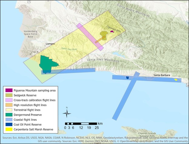
SHIFT: Vegetation Plot Photos, Santa Barbara, CA, USA, 2022
National Aeronautics and Space Administration —
This dataset contains photographs of the plots where field vegetation sampling was conducted during the 2022 NASA Surface Biology Geology (SBG) High Frequency Time... -
Federal
BOREAS Follow-On FLX-04 Tower Flux and Meteorological Data from NSA Burn Site
National Aeronautics and Space Administration —
Tower flux and meteorological data were collected above 4 black spruce forest sites in the NSA that experienced stand-replacing wildfires in 1989,1981,1964 and 1930.... -
Federal
BOREAS Follow-On DSP-09 Saskatchewan Raster Forest Fire Chronology, 1945-1996
National Aeronautics and Space Administration —
This data set contains a pair of raster images and a spreadsheet chronicling the most recent fire history of Saskatchewan from 1945 to 1996. This data set was... -
Federal
BOREAS Follow-On DSP-10 Regridded TM Mosaic Land Cover Maps for 1994
National Aeronautics and Space Administration —
Existing 30-m land cover Thematic Mapper classification by CCRS was aggregated and reprocessed and are now available at multiple resolutions (10x5 minutes and 30... -
Federal
PnET-BGC: Modeling Biogeochemical Processes in a Northern Hardwood Forest Ecosystem
National Aeronautics and Space Administration —
This archived model product contains the directions, executables, and procedures for running PnET-BGC to recreate the results of: Gbondo-Tugbawa, S.S., C.T. Driscoll... -
Federal
BOREAS Follow-On HMet-03 Hourly Meteorological Data at Flux Towers, 1994-1996
National Aeronautics and Space Administration —
Point data developed from in situ observations at four flux tower sites were combined to produce continuous, above the canopy, meteorological forcing data sets.... -
Federal
VEMAP 2: U.S. Annual Climate Change Scenarios
National Aeronautics and Space Administration —
Data sets of transient climate change scenarios based on coupled atmosphere-ocean general circulation model (AOGCM) transient climate experiments with transient... -
Federal
VEMAP 1: U.S. Site Files
National Aeronautics and Space Administration —
An integrated input data set for ecosystem and vegetation modeling for the conterminous United States: Site Files -
Federal
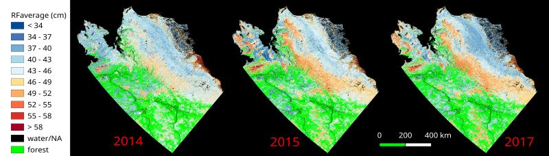
ABoVE: Upscaled Active Layer Thickness in Northern Alaska, 2014-2017
National Aeronautics and Space Administration —
The dataset consists of maps of estimated Active Layer Thickness (ALT) at 30-m resolution throughout the northern half of Alaska for the years 2014, 2015, and 2017.... -
Federal
BOREAS Follow-On DSP-04 1994 ERS-1 Level-4 Landscape Freeze/Thaw Maps, Ver. 1.0
National Aeronautics and Space Administration —
The BOREAS DSP-4 team acquired and analyzed imaging radar data from the ESA's ERS-1 over a complete annual cycle at the BOREAS sites in Canada in 1994 to detect... -
Federal
BOREAS Follow-On FLX-03 Area-Averaged Flux Data for the NSA and SSA
National Aeronautics and Space Administration —
Calculations of area-averaged fluxes using extracted flux data from BORIS. -
Federal
Ecosystem Demography Model: Scaling Vegetation Dynamics Across South America
National Aeronautics and Space Administration —
This model product contains the source code for the Ecosystem Demography Model (ED version 1.0) as well as model input and output data for a portion of South America... -
Federal
Biome-BGC: Terrestrial Ecosystem Process Model, Version 4.1.1
National Aeronautics and Space Administration —
Biome-BGC is a computer program that estimates fluxes and storage of energy, water, carbon, and nitrogen for the vegetation and soil components of terrestrial... -
Federal
VEMAP 2: U.S. Daily Climate, 1895-1993
National Aeronautics and Space Administration —
VEMAP Phase 2 has developed a data set of ~100-year gridded monthly and daily time series of climate for the conterminous United States that includes realistic... -
Federal
BOREAS Follow-On DSP-10 Regridded Peatland Maps
National Aeronautics and Space Administration —
These images were produced by aggregating 1' gridded data layers derived from the polygon-based Peatlands of Canada Database (Tarnocai et al., 2000) to 10'...

Official websites use .gov
A
.gov website belongs to an official government
organization in the United States.
Secure .gov websites use HTTPS
A
lock (
) or https:// means you’ve safely connected to
the .gov website. Share sensitive information only on official,
secure websites.